http://goo.gl/maps/ullBk
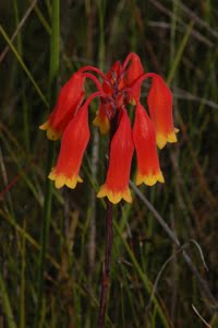
As it happens, I was out there yesterday afternoon, checking the development of the Illawarra Bird Orchids which grow on the Budderoo National Park. They were all forming their little leaves, hugging the ground.
Today, those plants were burnt.
Oh well, such things do happen (naturally).
I guess, it will give me an opportunity to monitor the recover from fire, of these plants.
 |
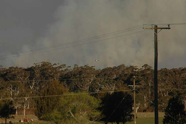
| Two cloud peaks, marking "hot spots" of the fire below. The smoke was visible from Robertson village. But this view is taken from Fountaindale Road, which leads down below the village, towards the Upper Kangaroo River valley (below Carrington Falls) |
 | |
| Coming back from the Barren Grounds, this was what the sun looked like, through a dense patch of smoke. Clearly the patch of fire generating this dark smoke was an area where the fire was "crowning". Presumably a patch of Eucalypt trees burning, rather than the heath growth which characterises most of the growth in that area. |
 |
| A wider view of the same column of smoke, rising in the distance behind the roadside trees. |
 |
| Taken from near the Jamberoo Road lookout point But taken looking not over the cliff view, but back towards the Barren Grounds. |
 |
| Banksia heath more or less burnt to ashes. |
 |
| Form the "Gate" on the Budderoo Fire Trail looking south-west, out along the Budderoo Plateau. |
 |
| Budderoo Fire Trail used to define the edge of the "Burn-off" Left side unburnt Right side all the heath has burnt, but not the taller trees. |
 |
| Illawarra Bird Orchid leaves (2 plants) |
 |
| The fire seen from Cloonty Road, beyond Carrington Falls looking south-east, towards the Budderoo Plateau, |
 |
| Similar view of the fire. Click to enlarge There is a Helicopter just visible, above the trees. Probably about 5 Kilometres away. |
********************
UPDATE: 10:00am Wednesday 5 September.
Radio reports say this fire has jumped containment lines, on the western side. Fortunately, the expected winds ought be from the north-west, apparently, so that ought cause the fire to burn back on itself.
However, strong winds are unreliable when it comes to fires.
 |
| Fire as seen from Fountaindale Road. Fire seen from the same place as Photo 1 which was taken on the day before. |
Lets hope it works out OK.
However, strangely, the RFS website gives the status of this fire as follows:
Budderoo Fire
ALERT LEVEL: Advice
LOCATION: Budderoo National Park, 7km west of Jamberoo
COUNCIL AREA: Kiama
STATUS: Out of Control
TYPE: Scrub fire
FIRE: Yes
SIZE: 140 ha
RESPONSIBLE AGENCY: NSW National Parks & Wildlife Service
UPDATED: 5 Sep 2012 06:25
ALERT LEVEL: Advice
LOCATION: Budderoo National Park, 7km west of Jamberoo
COUNCIL AREA: Kiama
STATUS: Out of Control
TYPE: Scrub fire
FIRE: Yes
SIZE: 140 ha
RESPONSIBLE AGENCY: NSW National Parks & Wildlife Service
UPDATED: 5 Sep 2012 06:25
The strangest part of all is that they do not describe this fire as a Hazard Reduction Burn (unlike many other fire reports on the same website).
The Bureau of Meteorology has a Fire Weather Warning, which it has been publicising for two days.
Latest update: 10:15 am
Jamberoo Mountain Road closed at the Pie Shop corner.
http://livetraffic.rta.nsw.gov.au/desktop.html#mapview
Click on the Fire symbol, south from Wollongong and a pop-up screen will appear, as long as this situation remains current.
***************
Further Update Thursday 6 September
Fire appears to be out.
No doubt some smouldering going on.
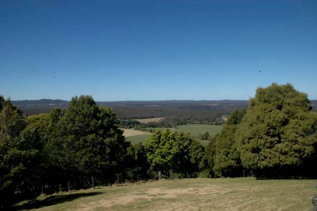 |
| Same location as previous distant views Thursday morning |
 |
| Zoomed view - no sign of smoke |
5 comments:
At least with this fire the matchbox boys appear to have kept it within their intended boundaries.
Hopefully the heath will regenerate as a mixed heath. What tends to happen in this area is that some species - Kunzea ericoides here, Daviesia mimosoides in other areas - which require scarification of their seeds benefit from the fires and head towards a monoculture. Unfortunately they grow quickly and burn very readily so the hazard builds up more quickly.
I do of course realise that 'something' has to be done to prevent loss of human life from wildfires. I just wish someone would come up with a solution that didn't involve the loss of a whole lot of other life. Having the fires at times other than peak flowering and nesting time would be a good start!
Here endeth the rant.
Martin
We took some extraordinary photos of the burn-off from up here last night. I will try to post them on FBxxCeleste
Thanks Martin and Celeste.
I look forward to seeing your photos Celeste.
Martin, rant welcomed. In this area, the main heath shrubbery is in the Epacris tribe, and many Banksias. There are some Pea family plants, but they do not dominate here (at present).
I do know that in areas with regular fires, the Peas do tend to dominate, because they survive fires well (by seed germination), and promote fires through their leaves being highly flammable.
Local News is saying that the fire has jumped the containment line to the western side. That is being worked on as I write, apparently. But the good news, (if there is any) is that the winds expected are due to be north-westerlies. So that ought push the fire back on itself.
But such things cannot be guaranteed.
Lets hope it all works out OK.
There are only a few private properties out further on that Plateau - but much further out than the fire had reached yesterday. Lets hope it works out OK for them.
It puzzles me why hazard-reduction burning is conducted in spring. This is the breeding period for most wildlife & when there are helpless young, unable to escape from fires. I realise no time is going to be ideal, but surely late summer or early winter would have significantly less impact on wildlife?
One would also hope that given the current weather conditions, that further hazard reduction burning this spring will be put on hold?
Hi Tony.
Thanks for asking the question that needed to be asked.
All I can say is that the NPWS guy who would normally conduct these burns is away at present.
I am reluctant to comment further without detailed consultation.
I do know the RFS were on the air this morning claiming credit for having controlled the fire. When I was present I only saw NPWS officers.
Is that inter-agency rivalry?
Surely not.
>
The Eastern Bristlebird which lives right at that point is listed on Federal and State Threatened Species lists>
http://www.environment.nsw.gov.au/threatenedspeciesapp/profileData.aspx?id=10206&cmaName=Southern+Rivers
Did anyone consider them prior to lighting this fire?
I don't know.
I do acknowledge that the narrow area of the planned burn-off ought minimise the impact on that bird species. At least they have some (limited) mobility.
.
But I am seriously annoyed that the plants I photographed (which have zero mobility) have been burnt. They were directly burnt by a drip torch or whatever system they use.
They could have lit the area 2 metres further in, and achieved the same overall result, without burning the best colony of that Bird Orchid known to exist.
http://peonyden.blogspot.com.au/2008/07/few-more-photos-of-bird-orchid.html
I have shown these plants to the main NPWS officer responsible for this area. But when he is away, who knows (or cares) what gets burnt?
Its tough dealing with a blind Bureaucracy.
Denis
Post a Comment